Chapter 11: The Great Plains

The Great Plains


Many areas of the Great Plains have experienced population loss in recent years, or have grown more slowly than other parts of the U.S and Canada. Young people have left the region in large numbers because of the economic and cultural opportunities available in urban and suburban areas. The region lost 20% of its population between 1990 and 1995. Today, much of the counties in the Great Plains now have high population of older residents. The percentages of elderly in the Great Plains is highest in North America. This has generated many social problems such as access to medical services, fewer physicians, pharmacists, dentists, churches no longer have congregations large enough to support them, loss of customers for businesses, etc. 
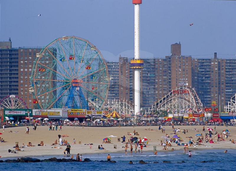


New York City
Age and Sex of Residents in zip code 11211
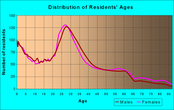
2011: Population Distribution in New York City


Unlike the Great Plains region, New York City has experienced an increase in their population of the young generation within the 20th century. New York City may be an expensive place to live, jobs are not easy to find, and transportation is not always comfortable nor reliable. But despite these challenges, the city continues to grow especially with the younger generation between the ages of 23-30 years. Perhaps because of media influence, high economy, and fun, attractive sites that are home to New York, young people want to live in this area. Every borough in New York City has registered a gain in population. The population increase furthers the need for more affordable apartments and job opportunities. The influx in population also results in a benefit for businesses because of more customers in the area. As people migrated to New York in the recent century, other states experience a loss in their population. An influx of foreigners combined with a decline in the loss of migrants to other states led to the population growth in New York City. 


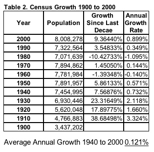
Growth in New York City


http://www.city-data.com/zips/11211.html
http://www.nytimes.com/2014/03/27/nyregion/population-growth-in-new-york-city-is-reversing-decades-old-trend-estimates-show.html?_r=0

Chapter 12: The Rocky Mountain Region

The Rocky Mountain Region


The Rocky Mountains paint an extraordinary view, creating one of the most dramatic landscapes in the world. The mountains are characterizes by snowy peaks, high meadows, and deep valleys. It extends nearly 2,000 miles from central New Mexico to northeastern British Columbia. The mountains contain some of the highest peaks in the United States. Many of the Euro-American settlers of the Rocky Mountains were seeking natural resources in the region and were traders, trappers, and hunters. Today, the region is always visited by tourists and new residents that are interested in the quality of life that the climate, open scenery and space provides. It is also one of the fastest growing places in United States. Much of the mountain was created through erosion, volcanic activity, and glaciers. 


New York: Mount Marcy

Although New York may not be known by their natural habitat because of the industrialized cities, the state still is home to many mountain regions. The highest peak in New York is Mount Marcy. It is the highest point in New York state and has an elevation of 5,343 feet. It is a popular destination for hikers because of its grand view and stature. The majority of the mountain is forested with many trees. The peak of the mountain has many alpine shrubs, lichen plants, and has rocky crops. The most frequently used trail by hikers is called the Van Hoevenberg Trail. It is 7.4 miles long and is suitable for snow activities. It is a very big rock-dome and some of the best views in the north-east region. It is home to a small amount of endangered vegetation that is about 85 acres. 


Chapter 13: The Intermontane West

The Intermontane West


Copper Mining

The Intermontane West lies between the Rocky Mountains and the Sierra Nevada and Cascade ranges. It covers a tremendous amount of area and is large in terms of its economic, environmental, and cultural importance. It is home to the Grand Canyon, the most famous back-packing trails in the country, is a Mormon county, one of the most unique Native American cultural landscapes in the U.S, contains large power plants and dams, grand rivers and much more. Mining became the primary economic activity in many portions of this region. Discoveries of gold, silver, and copper brought many miners into the areas. As the popularity of mining grew, many people became to move into mining communities to earn more for their living. Copper is the most valuable precious metal of the Intermontane West. Although there less of contribution to mining today, it still remains a significant part of the region.


Copper Mining


Copper Mining


New York City


Mining is a primary economic activity in the Intermontane West region. Although mining may not be a primary activity for their economy, New York State comes in as part of the top third among all the states in the value of its mineral production. Its mineral's resources make a huge contribution to the state's total economy. Most of New York's mining include digging of sand, gravel, and limestone. The minerals are then processed through crushing and are used in concrete, blacktop, roadfill, and other construction projects. New York State has many reserves of salt, talc, zinc, wollastonite, emery, and garnet--different types of minerals. These minerals are used for sandpaper, wallboard, paint, ceramics, brick making, and glass. These mines are located all throughout the state of New York. The leading minerals that are produced in this state are crushed stone, limestone, salt, construction sand & gravel, and Zinc. The total value of all these minerals amount to $1.5 million which brings the state to fifteenth place in the ranking for the production of non-fuel minerals. New York is the only state that produces wollastonite (a mineral that contains small amounts of magnesium, iron, and manganese). Ranks second for the output of garnet and zinc. Ranks third for the production of salt, and fourth for the mineral tarc. 


Wollastonite


http://www.dec.ny.gov/lands/5045.html

Chapter 14: MexAmerica

Chapter 14: MexAmerica


The MexAmerica region extends across a wide variety of physical environments. It includes large areas such as Pheonix, Tucson, El Paso, San Antonio, and Texas. It is not defined by common physical or economic characteristics yet it is a region that is rapidly growing. Many people who live in this region share the same Latino ancestry and culture. The Rio Grande is a physical boundary of the MexAmerican region and west of El Paso is a geometric boundary. The landforms represent southern extensions of the mountain ranges to the north of MexAmerica such as the Rocky Mountains. Much of this area is arid and rugged with mountains and isolated peaks. East and South of Big Bend National Park, the land becomes less rugged and is much flatter.


A common characteristic of the entire region is its hot, dry weather. The mountains of California and northwestern Mexico block much of the moisture coming onshore from the Pacific Oceans. Areas east of these mountains are extremely dry. Some of the driest regions are Death Valley, California; Mojave Desert, Sonoran Desert, and the Chihuhuan Desert of eastern Arizona. A key feature of the Mojave Desert and the Sonoran Desert is the desert tortoise. This reptile is the official state animal of two states that are a part MexAmerica. Desert tortoises live in the deserts of MexAmerica and are able to live where ground temperature may exceed 140 degrees F. These giant tortoises could grow up to 14 inches and they are able to adapt to the heat because they dig underground burrows to escape the high temperatures. At least 95% of their lives are spent in burrows to protect themselves from the heat as well as freezing temperatures. A threat to this reptile is poaching for sale in the pet trade, habitat fragmentation, and habitat destruction as land continues to develop. Today, the population of desert tortoises have declined as much as 90% since the 1980s. However, it is unlawful to hunt, harm, harass, or collect the wild desert tortoise.


New York


Just as the desert tortoise is known as the state reptile for two states in the MexAmerican region, the beaver is the official state animal for the state of New York. The beaver was adopted as the state animal in 1974. Beavers are unique animals with broad, scaly, and flat tails and lustrous fur with the capability to change a landscape that is second to humans. They have webbed hind-feet, poor eyesight, but a great sense of hearing, smell, and touch. They live in dam streams in shallow valleys and prefer flooded areas that stream into wetlands. They are important to natural water flow and erosion control because beavers build dams in order to create ponds in which they live. These are called beaver lodges and they serve to protect the beavers from coyotes, wolves, and bears. Beavers work by carrying mud and stones with their paws and timber between their teeth and they usually work during the nighttime. Their favorite food is the water-lily which grows at the bottom of lakes and rivers. 


http://www.statesymbolsusa.org/New_York/animal_beaver.html

Chapter 15: California

California


California is notorious for its surfers, sandy beaches, Holly wood stars but is also known for its crime, traffic, and urban sprawl. California has a mostly Mediterranean climate characterized by cool and occasional rain during winters and long summers with warm to hot temperatures and little to no precipitation. California's population increased during the 1800s when gold was discovered in the Sierra Nevada foothills once the U.S gained control of California after the Mexican war. The cities of San Francisco and Sacramento were major supply points of gold and there were many settlers who sought after the gold rush. California is also known for its highly diverse agriculture. It produces all of the nation's dates, figs, kiwis, olives, nectarines, strawberries, almonds, walnuts, and more. California is also the center of production for many motion pictures, radio and T.V programs, and popular music.


California is also widely known for earthquakes. Its location is at the boundaries of North American and Pacific plates which makes it responsible for its dramatic mountains and valleys, earthquakes, volcanoes, and landslides. The movement of the Pacific Plate created a series of lateral faults (strike-slip faults) along the California coast. The movement along these faults is horizontal and the most famous is the San Andreas fault. One the thousands of earthquakes that caused much damage is the Northridge earthquake. On January 17, 1994 occurred a major earthquake of a 6.7 magnitude that produced the strongest motion ever recorded in North America. Parking structures were crashed, major freeways collapsed and apartment buildings were ruined. Areas that were particularly impacted were the San Fernando Valley and Santa Monica. Geologists say that they had been predicting an earthquake such as these for years before it occurred. 

New York
Although eastern United States is not known for its earthquakes as regions that are near plate boundaries, earthquakes do occur there. Earthquake rates are about 50 to 200 times lower than in California. But earthquakes that do occur here are typically felt over a much broader and wider region than earthquakes in the west of the U.S. Thus, damage of the earthquake could also be larger. Geologists and scientists state that earthquakes that happen in New York could be due to stress that is derived from present day rifting at the Mid-Atlantic ridge. Just as California experienced severe from a naturally occurring disaster, New York was also impacted by a natural disaster known as Hurricane Sandy. 


Hurricane Sandy severely affected New York in 2012. There was flooding of the New York City Subway system, many suburban communities, road tunnels, homes and businesses were destroyed, hospitals and centers were closed and evacuated, and as least 55 people died as a result of the storm. An estimated amount of 250,000 vehicles were destroyed by the hurricane and the economic losses as a result was at least $18 billion. After Hurricane Sandy occurred, there was much relief and support from the nation as well as rescues and evacuations. For example, a relief fund was created for residents in the Staten Island area provided by the United States Homeland Security. Funds were also given from Time Warner Cable, Red Cross, as well as the state of New York itself. Today, New York has recovered from this disaster and has overcome many losses due to Hurricane Sandy.


http://en.wikipedia.org/wiki/Earthquake_activity_in_the_New_York_City_area
http://en.wikipedia.org/wiki/Effects_of_Hurricane_Sandy_in_New_York

Chapter 16: The Pacific Northwest

The Pacific Northwest


Willamette Valley


The Pacific Northwest region is one of the most isolated regions in North America, separated from the rest of the continent and world by high mountains, remote coastlines, and dense forests. It also has the continent's only active volcanoes. The natural beauty of this region has contributed to a deep sense of environmental identity that is characteristic of many people who live in this area. Its cool, rainy climate is also a unique characteristic to North America. The Pacific Northwest includes western Oregon, western Washington, British Columbia, west of the Rocky Mountains, and the southeastern panhandle of Alaska. To the west is the Pacific Ocean, and the Klamath Mountains lies to the south, which divides northern California from southern Oregon. The Rockies and the Cascades lies to the east and they converge on each other. 


Microbrewery


The Pacific Northwest became the center of the craft beer movement that is now flourishing and spreading across the United States, Canada, and the rest of the world. In the 1970s, a couple of brewers in Oregon, Washington, and British Columbia became tired of the traditional American beers so they began to explore different ways of making better beer brewed from local ingredients. These were then called "microbrews." There are over 1700 breweries that are responsible for the many beer brands existing in the United States. 6.3 percent of overall beer sales in the United States came from craft brewers in 2008. The state of Oregon is the center of the microbrew production in the Pacific Northwest. This is because it is the largest craft-producing state, generating over 9 million barrels in 2010. Oregon has 82 brewing companies, and it operates 114 brewing facilities in many of its cities. The boom in the craft beer brewing industry is a successor to the fur, fishing, and timber industries. A common phrase that is often stated in Oregon is, "Save a tree and drink a northwest local beer."


New York


The influence of the brewing success in the Pacific Northwest has carried onto the state of New York as New York state holds home to a brewery that distributes beer to 25 states and 20 countries. Since its founding in 1988, Brooklyn Brewery has brewed flavorful beers that caters to the fulfillment and enjoyment of its customers and communities. It is an award-winning brewery and stands as one of the top craft beer producers in the world. Throughout 2011-2013, Brooklyn Brewery underwent an expansion that has quintupled its overall capacity. This makes this brewery to have the potential to export more beer than any other American craft brewery. Some of the other Craft beer bars that have been recognized in New York city are: Bierkraft, Good Beer NYC, Top Hops, and New Beer Distributors. New York City often holds "Beer Weeks" to advocate and promote awareness of its local brewing members; to increase the awareness of local beers through various programs, events, and education; and to foster a healthy and ethical beer industry throughout the entire city. 


Chapter 17: Hawai'i and the Pacific Islands

Hawai'i and the Pacific Islands


Hawaii is the symbol of a tropical paradise to many people around the world. Its images include sandy beaches, swaying palm trees, flowers, hulas, surfing, macadamia nuts, ocean breezes, pineapples, and many more. While qualities make Hawaii a very popular place for tourism, others may associate this region with Pearl Harbor; an attack from Japanese planes upon the U.S headquarters on December 7, 1941. The state of Hawaii is a chain of islands and volcanoes that extend 3,600 miles from the "Big Island" of Hawaii to the Aleutian trench off Alaska. It consists of eight inhabited islands near the Pacific Ocean: "Big Island," Kahoolawe, Maui, Lanai, Molokai, Oahu, Kauai, and Niihau. 


Oahu


The island of Oahu along with its major city, Honolulu, leads the state's economy and politics. The city and county of Honolulu includes the entire island of Oahu, and two-thirds of the state's resident live here. Some of its characteristics are crowding, commercialism, pollution, and traffic jams. It is home to Waikiki Beach--the world's most famous resorts containing luxury hotels, restaurants, shops, boutiques, and other tourist spots. 


The "Big Island"


The "Big Island" of Hawaii is the largest of all the islands on the state. It contains two-thirds of the state's land area. It is the youngest of all islands and is the one most pertinent to volcanic activity. It's largest city, Hilo, is the island's major seaport and commercial center. One of the island's dormant volcano, Mount Kea, can be seen from Hilo on a clear day. The top of the volcano has the world's leading astronomical observatories, including the National New Technology Telescope. On the southwestern side of the "Big Island," there lies the Kona coast. This area is the Big Island's leading tourist center in which there has been an influx of retirees from various regions in the U.S and Canada. 


Maui


The Maui region of Hawaii is the fastest growing part of the entire state. Two of its cities--Wailuku and Kahului--contains most of the island's shopping centers and traffic. Maui is experiencing rapid population growth as well as scarcity for new land development, expensive housing costs, traffic, and air pollution. Another city called Molokai is very unique to the state because it has been unaffected by development and tourists do not visit here. This is because there are no traffic lights, air conditioners, elevators, or fast-food restaurants. Lanai is a city also located in Maui that is home to the successful business of the Dole pineapple plantation.


Kauai


Kaui is the oldest of the islands in the state of Hawaii. It is known for its amazing scenery and vulnerable climate. Some of its attractions include Waimea Canyon which contains dense rain forests and beautiful waterfalls. It is the first Hawaiian island that was discovered by the islanders from Polynesia. The island expresses concerns that tourism will potentially destroy its spectacular scenery and cause more pollution and overcrowding. It is home to Papahanhanaumokuakea Marine National Monument which the largest conservation area under the United States and one of the biggest marine conservation areas in the world.


New York


Although New York City may not be known as a "tropical paradise" as that of Hawai'i, that does not mean it is not without many natural attractions. New York City contains many sand-filled getaways. In addition to the three principal islands of New York City--Long Island, Manhattan and Staten island-- each contains smaller islands of their own. The Bronx contains 4 islands of its own: The Pelham islands, North Brother, South Brother, and Rikers island. Brooklyn's islands are: Canarsie Pol, Ruffle Bar, and Mau Mau island. Manhattan has seven islands some of which are called Ellis island and Governor's island. Queen's island also has two islands called Ruler's Bar Hassock, and Ruffle Bar. Lastly, Staten Island has five islands within its borough which are called: Hoffman island, Isle of meadows, Prail's island, Shooter's island, and Swinburne island. Within the natural sea attractions of New York City lies many beaches that are popular within the community. 


Coney Island, Brooklyn


Coney island is two and a half miles along the Atlantic Ocean. It is also the easiest beach to access from most of New York City. In 1824, Coney Island was established as a seaside resort which began attracting many visitors and tourists. After the Civil War, there was an increase in attractions on the island itself such as restaurants, hotels, shops, amusement rides, theatres, and more. At the end of the century, Coney Island offered rides, concessions, and much more entertainment on a spectacular scale. Coney Island is a place that offers great and exciting recreational opportunities all year-round.


South Beach, Staten Island


The South Beach, otherwise known as the Franklin Delano Roosevelt Boardwalk has been providing many New Yorkers peace and tranquility from the congestion of the city life. With many hotels, theaters, beer gardens, carousels and ferris wheels, the beach has become a phenomenal resort. In 1935, New York City acquired the land property of the beach as part of President Roosevelt's "Work Progress Administration." While providing jobs during the era of depression, this project revived the community of South Beach.

Rockaway Beach, Queens


Rockaway Beach is seven and a half miles on the Atlantic Ocean. Along the boardwalk lies basketball courts, handball courts, roller-hockey rinks, and play ground areas that visitors may enjoy. Recent installment of a whale sculpture titled "Whaleamena" has been a popular addition. Under the direction of the park commissioner in the 1930s, the completion of two bridges led to the growth of Rockaway. Marine Parkway bridge and Cross Bay Bridge connected Rockaway to Queens and Brooklyn. Today, this beach is widely used by all people for their enjoyment and pleasure.


http://www.nyc.com/best-of-new-york/beaches_in_new_york.s1488/
http://en.wikipedia.org/wiki/List_of_smaller_islands_in_New_York_City